North Caribou River
-
Overview
Property Type• Shear-hosted Gold
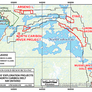
Size• 1073 Ha, 55 single cell mining claims
Status• 100% owned by Romios Gold Resources Inc.
• 1% NSR to 3 individuals
Exploration Stage
• Currently grass-roots work adjacent to a heavily drilled fault structure.
Location
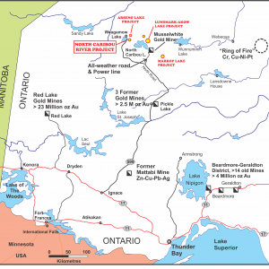
• 515 km north of the city of Thunder Bay and 170 km north of the town of Pickle Lake in NW Ontario.
• 14 km SE of the road accessible North Caribou Lake First Nations community of Round Lake (a.k.a. Weagamow Lake).
• 11 km east of the all-weather road and major power line into Round Lake. -
Geology/Exploration
Highlights of Key Target Areas
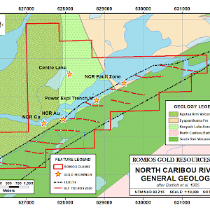
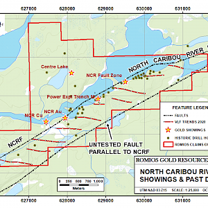
Romios’ North Caribou River claims cover one of the most mineralized sections of the North Caribou River Fault (NCRF), a >15 km major NE-trending fault that separates NE-trending South Rim basalts and gabbro to the south from the N-S trending Keeyask Lake and Agutua Arm volcanic assemblages to the north, as well as the ~E-W trending Eyapamikama sediments that form the axial core of the North Caribou Lake greenstone belt. Extensive exploration along the NCRF in the 1970s-80s included the drilling of over 60 holes and led to the discovery of scattered high-grade Au+/-Cu showings and locally broad zones of impressive alteration and sulphidation.
The best historic prospects include:
- Power Exploration’s Trench “M” consisting of numerous en echelon galena-chalcopyrite-quartz-carbonate-pyrite-pyrrhotite veins. Assays up to 1.79 oz/t Au were returned from grab samples and the full extent of the vein(s) is uncertain due to the water levels. The widest individual vein sampled was exposed for 9 inches and could be traced 14 ft.
- Guiness Gold intersected values up to 0.224 oz/t Au over 1.3 feet, 0.083 oz/t Au over 10.6 feet and 0.057 oz/t Au over 16.0 feet in 1989.
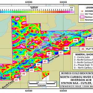
The past work did not include any significant attempt to test a parallel fault 800 m south of the NCRF or any splay faults that would be expected to form between these 2 faults. In many shear-hosted gold camps, the major deposits are not on the tight main faults, they form instead on the more “open” secondary splay faults coming off the main breaks. Analysis of an old VLF survey on a nearby prospect indicated the presence of E-W structures coming off the altered and locally mineralized NCRF. In 2020, Romios contracted Terraquest to fly a VLF-Mag survey specifically designed to locate any E-W conductive trends on the company’s claims. This survey located 10 apparent conductive linear structures between the 2 main faults.
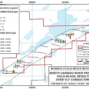
In 2021, Romios conducted soil sampling over 5 of the 10 VLF features. A modest but persistent gold anomaly was detected over one of the larger features and more sporadic, multi-element anomalies were detected on several others. Geological mapping revealed that the structural fabric approaching the most anomalous conductor rotated from NE to E-W as the conductor was approached, suggesting that there is indeed a splay fault in this area. A brief program (hampered by bad weather) of infill soil sampling on the main target conductor and new sampling over one other VLF feature was conducted in 2022; analytical results are pending.
Romios’ future work on these claims will include the completion of soil sampling and mapping of the very limited outcrops over the presumed splay faults, followed by hand trenching where possible, and potentially mechanised trenching and/or diamond drilling if warranted.
Prospect #1
KARL ZEEMAL ZONE #3
There is one historic gold showing in the area, located on the western end of the current Markop Lake claim block and known as Karl Zeemal Zone #3. This occurrence has been described as a stockwork quartz vein network hosted in sericitized feldspathic wacke that grades into conglomerate. It is located close to the eastern bounding fault of the Timiskaming style basin. The veins contain trace arsenopyrite and historic grab samples assayed up to 4,130 ppb Au and a 0.33 m channel sample assayed 23,905 ppb Au.
Romios’ one-day field examination in the area of this showing in 2022 did not locate Zone #3 itself (the area was burned in a large forest fire in 2011 and is now covered with extensive deadfall). However, a number of gossanous shear zones at the contacts between gabbros and ultramafics as well as in the metasediments were located and sampled; assays are pending.
-
Press Releases
Jun 20, 2022Jul 13, 2021Jun 16, 2021Mar 4, 2021Oct 22, 2020Jun 22, 2020Jul 6, 2017Dec 2, 2015
